Labor ministers have called it pork-barreling. The government has called it bad data. And council mayors have called it ad-hoc.
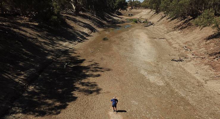
As farmers and their communities continue to suffer through severe drought conditions, the federal government has been keen to trumpet what it’s doing to help, which includes the Drought Communities Program, with Prime Minister Scott Morrison hinting at a fresh round of funding. 123 councils are eligible for more than $123 million worth of funding, with the latest 13 councils announced last month.
The only problem? How that funding is awarded is incredibly opaque. One eligible council has even been recently dealing with flooding.
How the government decides who’s worthy of funding and who isn’t has been shrouded in secrecy. So what’s the real story? How were councils deemed to be eligible — and was it fair?
The winners and the losers
The 13 successful councils were announced in late September — Murray River, Temora, Banana, North Burnett, Western Downs, The Coorong, Yorke Peninsula, Gannawarra, Moyne, Pyrenees, Strathbogie, Swan Hill and Kyogle. Each of these councils can apply for up to $1 million in funding for projects which lead to jobs for farmers and farm staff — this can include funding music festivals and even a virtual gym.
The government won’t explain why the funding was set at $1 million — councils are not eligible for more or less funding based on size or population. The Department of Infrastructure said the $1 million was designed to provide an “economic stimulus”.
But NSW Labor Leader Jodi McKay told Inq that doesn’t quite check out: “What we see happening now is a desperate scramble. The drought didn’t just sneak up on these governments … What’s clear is the state and federal Liberal-National governments have really dropped the ball.”
The 123 councils are spread across South Australia, Victoria, NSW, Queensland and Tasmania. Despite drought conditions across parts of WA and the Northern Territory, not a single drop of this funding made it west or far north.
How did we get here?
The government has been coy about the criteria used to determine eligibility. When Inq tried to get to the bottom of this with the Department of Infrastructure, a spokesperson had to (twice) revise their explanation:
“The Drought Communities Program Extension uses a dataset supplied by the Bureau of Meteorology — the Rainfall Deficiency Analyser Scheme. The Rainfall Deficiency Analyser Scheme provides percentile values of any consecutive 12-or-more month periods within a 24-month window up to a specified month.”
It’s a mouthful. Let’s break it down. The Rainfall Deficiency Analyser is no longer publicly available, but rainfall deficiencies are mapped. The Department of Infrastructure said regions with the lowest fifth percentile of rainfall met the threshold for funding. The Bureau of Meteorology (BOM) wouldn’t clarify how percentiles were calculated per region.
For the latest 13 local government areas (LGAs) to be allocated funding, the 24-month window was from June 2017 to June 2019. This is why Moyne, which flooded in August, was deemed eligible. The government admitted it used the wrong weather data, before re-running the numbers and re-declaring it was right in the first place.
There’s more to it than just rainfall, though, which gives the government some wriggle room in explaining who won funding. The spokesperson told Inq that the department also considered economic and industry data, including how many people in the area worked in agriculture, forestry or fisheries.
One thing that could clear all this up is drought coordinator Stephen Day’s report, which the government has not made public. BOM and the Department of Infrastructure have refused to release the data or exact methodology used.
A deep dive into the data
Without the exact methodology or data, it’s difficult to say with certainty whether the funding was awarded fairly. Luckily, monthly (and daily) rainfall is available on the BOM website for each station.
We added up the rainfall from each BOM station within an LGA for every month between June 2017 and June 2019 and found the average across the area. Notably, there’s not a huge contrast in the number of months of low rainfall between regions eligible for funding and those that aren’t.

Western Downs had four months of rainfall in the lowest fifth percentile; most of the 13 eligible LGAs had three. But Baw Baw, which did not qualify for funding, had five, while Central Highlands and Singleton also had three.
But using the average has its flaws — some LGAs are huge with dozens of BOM stations and significant rainfall disparity. Even when we examined individual BOM stations, there still wasn’t any notable difference between councils eligible for funding, and those that weren’t.
North Burnett (which received funding) had the highest number of distinct months of rainfall in the lowest fifth percentile across all individual stations, at 15 months; The Pyrenees and Gannawarra (also funded) had just one. Meanwhile, ineligible councils Scenic Rim and Singleton had 14 and 10 respectively, while Snowy Monaro had nine.
Even if we look at drought-declared areas (NSW, Queensland and SA state governments declare regions to be in drought, the rest of the country doesn’t), only one of the three regions to be awarded the most recent round of funding in NSW are in drought. Neither of the LGAs in South Australia are currently in drought.
This isn’t to say the regions aren’t in need of funding — or rain. It just shows that, even using the government’s own loosely defined methodology, questions remain.
What’s the difference between these communities? Who they voted for at state and federal elections.
Tomorrow: Inq looks into claims of pork-barreling.


“Pork barrelling? THis government?” Perish the thought, oink.
[Funny watching Q&A last night :-
Littleproud and “Food & Fibre Farm” lobbyist/proxy Nat Simson – both talking as if it’s eventually going to rain and everything will back to normal, like it was in the good ol’ daze? That this is simply one of those “Once in a lifetime droughts”? Their ‘life’ span? A gnat’s?
“Climate change? Of course we believe it!”???? BS.]
“…What’s clear is the state and federal Liberal-National governments have really dropped the ball.”
Gee, where’ve we heard that before.
What’s more interesting lately are the letters here and in the dailies from long time farm folk. The common theme is widespread rural annoyance at how poor farm managers who don’t provide in good years for the inevitable bad years keep getting assistance but good managers get nothing. Rural communities are also coming around to the idea of closing down farming regions that have become unviable.
Not many votes or photo ops in this unfortunate new world though. I’m my experience it’s rarely a good idea doling out vaguely targeted money to councils.
If they cut out the garbage and got on with supporting Australia we wouldn’t be in this mess.
Each and every Polly only looks towards their own position in the world. Polly’s play the game to insure their livelihood for now and when they end up being dumped. There is no real investment in building dams as there are in carbon credits, shares in solar companies, and wind turbines. If dams are built and there is an abundance of water to cover the hard times as well as the good times, how can a person make a living out of his/her shares on the water market? We have to be all realistic and until someone can work out how to manipulate the good times and make a good quid out of them without the hardship of working nothing will change. Likewise with electricity. The smart ones flogged of the power stations and promised they wouldn’t build new ones providing they could get their gritty little fingers into the working mans wallet. My, My how successful they have been.